
Share
Published 12:54 9 Jan 2018 GMT
Updated 19:50 9 Jan 2018 GMT
 Add us as a preferred source on Google »
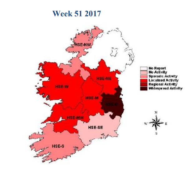 In week 51 (December 18 - 24) the capital, midlands and parts of the west were worst affected.
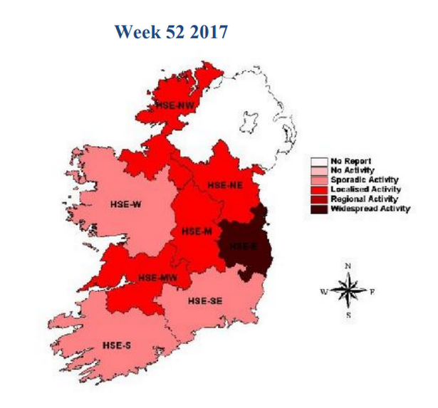 In week 52 (December 25 - 31), meanwhile, the flu appeared to have eased off in Galway and Mayo, while cases increased in Sligo and Donegal.
The flu outbreak is continuing to impact hospitals across the country, where hundreds of patients have been forced to wait on trolleys during this busy period.
The Irish Nurses and Midwives Organisation (INMO) estimates that there are 575 people on trolleys in Irish hospitals today, up 20 from 555 yesterday but down over 100 from a record 677 last Wednesday.
The worst-effected hospitals today are St Vincent's (37 on trolleys), Cork University Hospital (33) and Dublin's Mater Hospital (32).
Responding to the trolley crisis, Minister for Health Simon Harris has said that 2018 will be the "year of reform" for the Irish health system.
In week 52 (December 25 - 31), meanwhile, the flu appeared to have eased off in Galway and Mayo, while cases increased in Sligo and Donegal.
The flu outbreak is continuing to impact hospitals across the country, where hundreds of patients have been forced to wait on trolleys during this busy period.
The Irish Nurses and Midwives Organisation (INMO) estimates that there are 575 people on trolleys in Irish hospitals today, up 20 from 555 yesterday but down over 100 from a record 677 last Wednesday.
The worst-effected hospitals today are St Vincent's (37 on trolleys), Cork University Hospital (33) and Dublin's Mater Hospital (32).
Responding to the trolley crisis, Minister for Health Simon Harris has said that 2018 will be the "year of reform" for the Irish health system.